



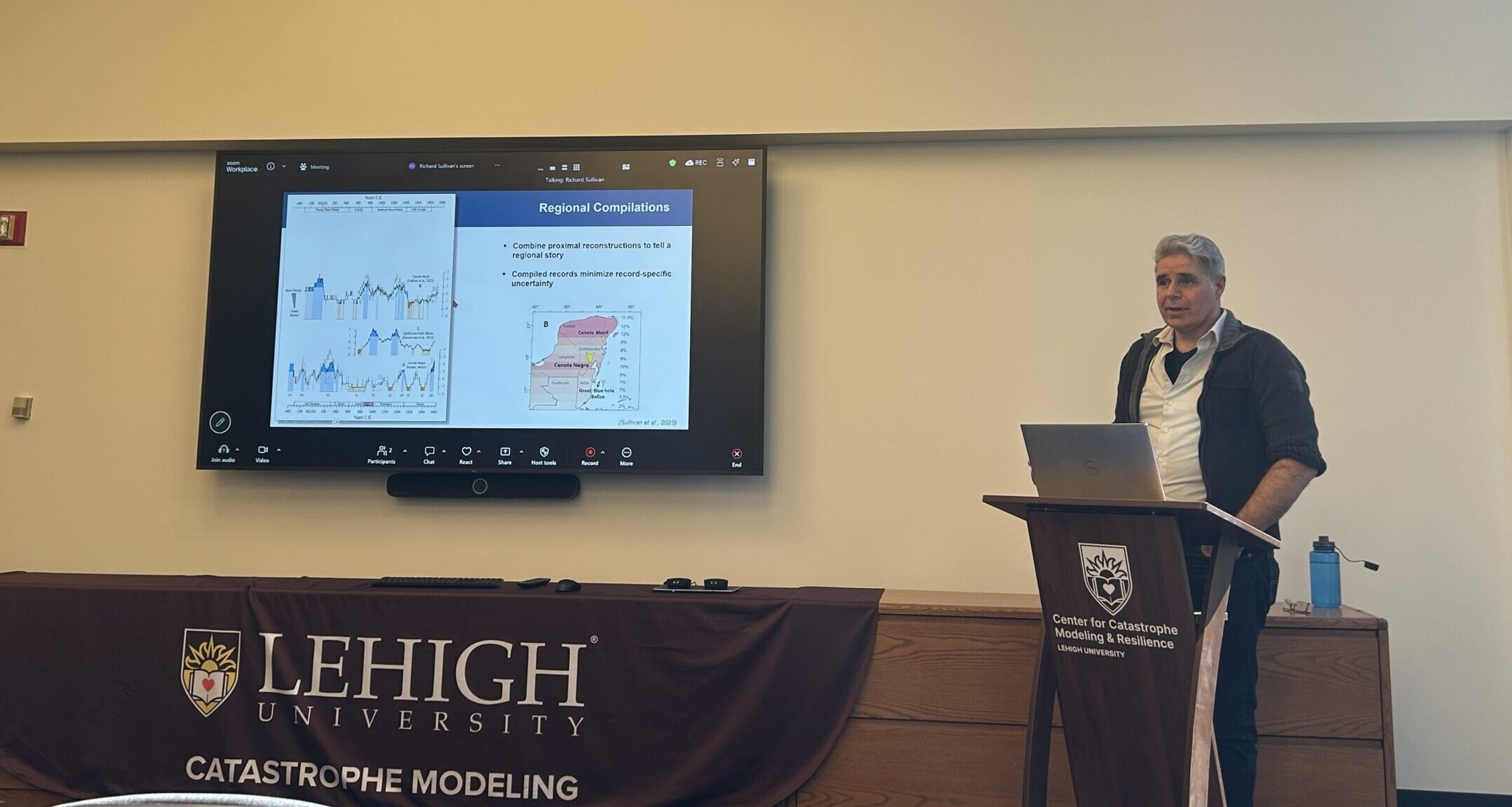
Richard Sullivan, a research scientist at the Center for Catastrophe Modeling and Resilience, began developing catastrophe models to understand Caribbean hurricanes based on varying annual climate conditions. Yet with modern satellite hurricane records only providing 50 to 60 years of historical data to reference, he turned to sediment cores.
Sullivan presented his research findings from the Center for Catastrophe Modeling and Resilience in Iacocca Hall on Lehigh’s Mountaintop campus Friday.
Looking for cross-regional geological evidence to link cyclone activity with climate patterns, he said he first turned to data from Spanish shipwrecks and speleothem growth in Scotland — mineral structures formed in caves by water deposition — and discovered a positive relationship between the two. In years with lots of shipwrecks, there was also high speleothem growth.
He found the common factor was rainfall.
Sullivan said when he graphed hurricane activity alongside shipwreck data and speleothem growth, he expected they would be similar.
He also said that was the moment he realized ships only sink where they travel.
Shipwrecks in a specific region of the world’s oceans wouldn’t be reflective of hurricanes in the wider region, or another area. The observational bias of this data became clear and he pivoted to sediment cores to expand his sample size of years and regions.
Sullivan said he then took two sediment cores from Cenote Negro, a freshwater sinkhole in the Yucatán region in Belize, extending his research sample to 2,400 years of past activity.
The cores showed finegrain mud and coarse grain deposits, which indicate changes in deposition patterns, which Sullivan and his team used to reconstruct a storm log.
Sullivan said the cores are useful measurement tools. He said as hurricanes pass over the area they move water, changing the deposition patterns which are preserved in the sediment cores.
He said there are still limitations with this model as well because the sediment cores were taken 40 meters away from each other and still have variance. Thus, Sullivan said, the cores only represent storm activity in the region they were taken from, and spikes in the sediment record may be the result of more or less powerful hurricanes depending on where they originated and traveled.
However, with this information Sullivan was able to compare geological evidence with computational and synthetic models he made of storm activity.
He said he created two different computer-based models — one demonstrating historical hurricane activity from 1940 and another modeling a preindustrial synthetic climate spanning 500 years.
Using these two simulation models, he said he generated thousands of storms to create self-organizing maps of hurricane activity and density plots to identify dominant climate patterns.
Sullivan said based on the data and dominant climate conditions that contribute to cyclogenesis, the process of extratropical cyclone development and intensification according to Brittanica, they identified six climate combinations that shaped distinct storm activity.
These conditions were a combination of vertical wind shear, sea-level pressure and sea surface temperature and accounted for seasonal variations.
He said vertical wind shear, the difference in speed and direction of the winds at varying altitudes in the atmosphere, was a very important factor in these climate models.
Sullivan was able to determine these variations in storm activity were due to normal climate conditions, not random chance.
These models can be used to estimate storm activity and hazardous conditions under different climate conditions in a specific region that year.
Sullivan received a question from the audience regarding the impact of human-caused climate change on these climate patterns. He said the storm patterns congruent with identifiable climate patterns, like El Niño, occur relatively the same whether driven by natural variability or anthropogenic influence.
Returning to the idea of regional difference, Sullivan said prolonged El Niño climate conditions would see decreased storm formation in the tropics, but storm origination would increase in other regions.
“For a permanent El Niño state, we would be less likely to see tropical cyclones forming in the tropics, but we would see more activity forming in higher latitudes,” Sullivan said.
Sullivan is also working on assessing local coastal community impacts of cyclones in New York supported by New York State Energy Research & Development Authority.
PhD students said they attended Sullivan’s presentation of his research to challenge and inspire their own research methods and work.
Urinrin Otite, ‘24M and ‘27 PhD, the first student to receive a master of science in catastrophe modeling and resilience at Lehigh, said she tries to attend these research talks that occur every two weeks, to influence her research on electrical grid resiliency.
She said her research is a hybrid of structural engineering, civil engineering and catastrophic modeling and resilience, and these talks keep her updated on recent research in these fields.
“I’ve noticed that whenever I attend, I get a new perspective on how to work on my research,” Otite said.
She said her main takeaway from this talk was about how cyclones progress, and she looks forward to future discussion with him about the impact of the surge and wind on structures onshore and offshore.
While her research is specifically focused on infrastructure development, she said it’s helpful to have multidisciplinary researchers and advisers in the catastrophe modeling center to consider different aspects of catastrophe impacts.
Ryan Chen, a first-year doctoral student in civil engineering at Lehigh, said his interest in catastrophe modeling stems from the flooding issue in New York City’s metropolitan area.
He said he’s interested in the risk and resiliency of cities regarding the large amount of uncertainty that comes with large-scale catastrophes.
Chen is from New York and had the opportunity to visit the East Side Coastal Resiliency Project in Manhattan, where they’ve begun to implement flood walls and natural barriers to protect against storm surges.
He’s currently working on a project that models the spread of wildfires. Chen said he attends talks to hear about a range of research topics to help him decide what he wants to explore throughout his doctoral program.
“There’s a lot of uncertainty when it comes to natural hazards and how our infrastructure and our systems will respond to those,” Chen said. “Being able to properly model (natural hazards) so that we are well prepared is pretty important.”
Comment Policy
Comments posted to The Brown and White website are reviewed by a moderator before being approved. Incendiary speech or harassing language, including comments targeted at individuals, may be deemed unacceptable and not published. Spam and other soliciting will also be declined.
The Brown and White also reserves the right to refuse the publication of entirely anonymous comments.